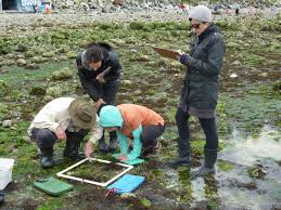
Shorekeepers Database
Trained volunteers and shorekeepers staff collect physical and biological data on chosen shoreline sites on Vancouver Island. The shorekeepers guide and protocol are used to monitor species composition and abundance of intertidal flora and fauna, in addition to mapping the physical characteristics of the surrounding habitat for the purpose of documenting baseline data as well as changes over a period of several years along our coast.
Simple
- Date (Publication)
- 1999-03-25
- Cited responsible party
-
Organisation name Individual name Electronic mail address Role Fisheries and Oceans Canada, Pacific Region, Regional Director' Office, Science Branch
Colin D. Levings
colin.levings@dfo-mpo.gc.ca
Originator
- Presentation form
- Hardcopy document
- Presentation form
- Digital document
- Presentation form
- Digital table
- Purpose
-
Long-term data set to support the detection of gradual changes to habitats and local biodiversity.
- Status
- ongoing
- Point of contact
-
Organisation name Individual name Electronic mail address Role Department of Fisheries and Oceans - OHEB
Glen Rasmussen
Glen.Rasmussen@dfo-mpo.gc.ca
Point of contact
- Maintenance and update frequency
- As needed
-
Government of Canada Core Subject Thesaurus
-
-
Earth sciences
-
Oceanography
-
-
Global Change Master Directory (GCMD) Science Keywords v15.9
-
-
Earth Science
-
Biological Classification
-
Animals/Vertebrates
-
Fish
-
Animals/Invertebrates
-
Oceans
-
Coastal Processes
-
Biosphere
-
Aquatic Ecosystems
-
Coastal Habitat
-
-
DFO Areas
-
-
North Pacific Ocean
-
South Inner Coast(Johnstone Strait, Strait of Georgia, Juan de Fuca, inlets and passages)
-
South Outer Coast(West Coast Vancouver Island)
-
- Access constraints
- Other restrictions
- Use constraints
- Other restrictions
- Other constraints
-
Access Constraints:Public#Use constraints:None
- Language
-
eng
- Topic category
-
- Oceans
- Environment
- Biota
- Environment description
-
Expected Growth Rate: Null
))
- Begin date
- 1997
- Supplemental Information
-
Custom software is available for use with this dataset.
- Reference system identifier
-
https://spatialreference.org/ref/epsg/
/
EPSG:4326
/
8.3
OGP Geomatics Committee 2013-11-18 OGP Geomatics Committee Geomatics Discipline Lead Denmark lks@iogp.org
- Distribution format
-
Name Version hardcopy document
Distributor
- Distributor contact
-
Organisation name Individual name Electronic mail address Role Department of Fisheries and Oceans - OHEB
Glen Rasmussen
Glen.Rasmussen@dfo-mpo.gc.ca
Distributor
- Fees
-
none
- Ordering instructions
-
contact Distributor
Metadata
- File identifier
- 4c06614a-407d-4b1f-9406-24f8d539191a XML
- Metadata language
-
eng
- Character set
- UTF8
- Hierarchy level
- Dataset
- Date stamp
- 2023-12-18T21:56:47.223Z
- Metadata standard name
-
North American Profile of ISO19115:2003 - Geographic information - Metadata
- Metadata standard version
-
NAP - CAN/CGSB-171.100-2009
- Metadata author
-
Organisation name Individual name Electronic mail address Role Fisheries and Oceans Canada, Pacific Region, Pacific Biological Station
Alison Smeaton
alison.smeaton@dfo-mpo.gc.ca
Author
- Other language
-
Language Character encoding French UTF8 English UTF8
Overviews
Spatial extent
Provided by