Alteration of fish habitat by natural and industrial sedimentation in macro tidal estuaries British Columbia, Canada
Anomalous patterns of sediment composition in the intertidalzone ofestuaries on the west coast ofCanada (British Columbia (B.C.)) help identify potential changes to the estuarine ecosystem owing to the sedimentation of fine-grained material from both natural and industrial sources. Changes in sediment input, as well as modifications of estuarine geomorphology, can result in unbalanced sediment budgets for specific parts of an estuary. Changes in the capacity of an estuary to process and distribute sediment maytherefore be a useful measure forecosystem alterations andthus, general fish habitat management.
Simple
- Date (Publication)
- 2001-09
- Cited responsible party
-
Organisation name Individual name Electronic mail address Role DFO
Colin Levings
Principal investigator Fisheries and Oceans Canada
T.F. Sutherland
Principal investigator The Korean Society of Oceanography
Y.A. Park
Processor The Korean Society of Oceanography
R.A. Davis Jr.
Processor
- Presentation form
- Digital document
- Other citation details
-
Special Publication in Proceedings of Tidalities 2000 ISSN 1225-1283
- Purpose
-
In this paper,we describeresultsfrom ecological studies of macrotidal estuarine environments from two settings in British Columbia (B.C.), Canada.
- Status
- Completed
- Maintenance and update frequency
- Not planned
-
Global Change Master Directory (GCMD) Science Keywords v15.9
-
-
Earth Science > Oceans
-
Earth Science > Oceans > Water Quality > Ocean Contaminants
-
-
DFO Areas
-
-
North Pacific Ocean > Fraser River and BC Interior
-
North Pacific Ocean > South Inner Coast(Johnstone Strait, Strait of Georgia, Juan de Fuca, inlets and passages)
-
-
DFO Areas
-
-
North Pacific Ocean > Fraser River and BC Interior
-
North Pacific Ocean > South Inner Coast(Johnstone Strait, Strait of Georgia, Juan de Fuca, inlets and passages)
-
- Language
-
English
- Character set
- UTF8
- Topic category
-
- Oceans
- Environment
- Environment description
-
1591 KB
- Description
-
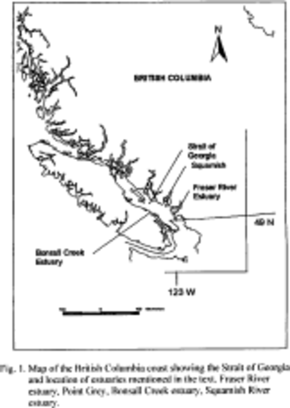
Fraser River estuary. Point Grey.Bonsall Creekestuary, Squamish River estuarv.
))
- Begin
- 1998
- End
- 2001
- Supplemental Information
-
Anomalous patterns of sediment composition in the intertidalzone ofestuaries on the west coast ofCanada (British Columbia (B.C.)) help identify potential changes to the estuarine ecosystem owing to the sedimentation of fine-grained material from both natural and industrial sources. Jetties and causeways, located on the largest tidal flats in B.C. at the Fraser River estuary, were found to 1) redirect the riverine suspended silt source in an offshore direction, 2) focus on-shore wave energy, and 3) cause a shift in sediment composition from mud to sand within the high intertidal zone of an intercauseway region. At a smaller B.C. estuary, Bonsall Creek, the deposition of gel-mud resulting from the discharge of particulate material from a water treatment settlingpond likelyaffectedthe distribution and abundance of vascular plantsand epibenthic and infaunal invertebrates within a tidal channel. Empirical data on the thickness of gel-muddeposits, loadings data, and a GIS analysis of tidal channels were used to compute possible deposition rates and area of impact. Estimated deposition rates at the landward head of the impacted tidal channel were significantly higher than maximum sedimentation rates estimated at two major estuaries: the Fraser River and Squamish River estuaries. Changes in sediment input, as well as modifications of estuarine geomorphology, can result in unbalanced sediment budgets for specific parts of an estuary. Changes in the capacity of an estuary to process and distribute sediment maytherefore be a useful measure forecosystem alterations andthus, general fish habitat management.
- Distribution format
-
Name Version electronic
none
- Distributor contact
-
Organisation name Individual name Electronic mail address Role Pacific Salmon Foundation
Isobel Pearsall
Distributor
- OnLine resource
-
Protocol Linkage Name WWW:LINK-1.0-http--link
https://www.dfo-mpo.gc.ca/science/data-donnees/index-eng.html DFO Science website
WWW:DOWNLOAD-1.0-http--download https://soggy2.zoology.ubc.ca/geonetwork/srv/api/records/70151b24-dda5-48db-adf5-8c07bfa6aef3/attachments/70151b24-dda5-48db-adf5-8c07bfa6aef3.pdf Proceedings of Tidalites 2000
WWW:DOWNLOAD-1.0-http--download https://soggy2.zoology.ubc.ca/geonetwork/srv/api/records/70151b24-dda5-48db-adf5-8c07bfa6aef3/attachments/70151b24-dda5-48db-adf5-8c07bfa6aef3.xlsx Tables
- Hierarchy level
- Dataset
- Statement
-
Levings produced paper copy. Fraser scanned with Fujitsu Scansnap s1500 (ABBY Finereader OCR software). Data was extracted through Adobe Reader conversion and manual entry into MS Excel.
Metadata
- File identifier
- 70151b24-dda5-48db-adf5-8c07bfa6aef3 XML
- Metadata language
-
eng
- Character set
- UTF8
- Hierarchy level
- Dataset
- Date stamp
- 2023-12-19T00:31:38.174Z
- Metadata standard name
-
North American Profile of ISO19115:2003 - Geographic information - Metadata
- Metadata standard version
-
NAP - CAN/CGSB-171.100-2009
- Metadata author
-
Organisation name Individual name Electronic mail address Role Pacific Salmon Foundation
Sarah Fraser
Author
- Other language
-
Language Character encoding French UTF8 English UTF8
Overviews
Spatial extent
Provided by