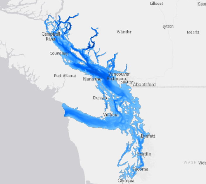
Salish Sea Bathymetry Basemap
Bathymetric Base Map for the Salish Sea Bioregion. Created for the Salish Sea Atlas ( https://wp.wwu.edu/salishseaatlas/).
Bathymetry for the Salish Sea. 3-arc second (approximately 90 meter) spatial resolution. Vertical datum: approximately Mean Sea Level.
Separate datasets for British Columbia and Washington data were downloaded from NOAA, converted from NetCDF to raster, and then combined as a Mosaic dataset using "blend" where they overlapped. The combined dataset was re-projected to UTM using Cubic Convolution resampling. The bathymetry dataset was snapped to align with the grid cells of the Salish Sea Atlas's Digital Elevation Model and clipped to the Salish Sea Atlas's Marine Waterbodies dataset. Low-lying coastal areas with missing data due to small mismatches in the coverage of bathymetry and elevation data in Canada were corrected by recalculating the elevation as 0 meters asl.
Simple
- Date (Publication)
- 2020-06-05
- Cited responsible party
-
Organisation name Individual name Electronic mail address Role Western Washington University
Aquila Flower
Point of contact
- Purpose
-
Bathymetric Base Map for the Salish Sea Bioregion. Created for the Salish Sea Atlas ( https://wp.wwu.edu/salishseaatlas/).
- Credit
-
Analysis and cartography by Aquila Flower
- Status
- Completed
- Point of contact
-
Organisation name Individual name Electronic mail address Role Western Washington University
Aquila Flower
Point of contact
-
Government of Canada Core Subject Thesaurus
-
-
Salt water
-
Ocean floor
-
Oceans
-
-
Government of Canada Core Subject Thesaurus
-
-
Salt water
-
Ocean floor
-
Oceans
-
- Access constraints
- licence
- Other constraints
-
License: Attribution-NonCommercial-ShareAlike 4.0 International CC BY-NC-SA 4.0. Details: https://creativecommons.org/licenses/by-nc-sa/4.0/. You are free to download, modify, and share this dataset for non-commercial purposes, but you must include a citation (such as "Salish Sea Atlas, Aquila Flower, 2021"). If you do use the dataset, I'd love to hear from you about how you're using it.
- Language
-
English
- Character set
- UTF8
- Topic category
-
- Environment
- Description
-
Salish Sea watershed basin
))
- Supplemental Information
-
Canadian data came from NOAA's British Columbia Bathymetric Digital Elevation Data.
US Data came from NOAA's Coastal Relief Model.
Note that this dataset was created using multiple datasets in different vertical datums. NOAA says that "the differences between these datums are less than the vertical accuracy of the CRM, so you can assign Mean Sea Level to this DEM if you like, just recognize that the elevation values may not be as accurate as you might like or need. Assume a vertical accuracy no better than 1 meter for any elevation values."
- Distribution format
-
Name Version dataset
1
- Distributor contact
-
Organisation name Individual name Electronic mail address Role Western Washington University
Aquila Flower
Distributor
- OnLine resource
-
Protocol Linkage Name WWW:LINK-1.0-http--link
https://salish-sea-atlas-data-wwu.hub.arcgis.com/maps/f23310e286614728a823ae84ab865cc1/about Salish Sea Bathymetry Basemap
ESRI:REST
https://tiles.arcgis.com/tiles/qboYD3ru0louQq4F/arcgis/rest/services/Salish_Sea_Bathymetry_Basemap/MapServer Salish Sea Bathymetry Basemap
WWW:LINK-1.0-http--related
https://wp.wwu.edu/salishseaatlas/ Salish Sea Atlas
- OnLine resource
-
Protocol Linkage Name DOI
https://doi.org/10.48689/a6118217-8940-41aa-b6f4-2542dcf54223 Digital Object Identifier (DOI)
Metadata
- File identifier
- a6118217-8940-41aa-b6f4-2542dcf54223 XML
- Metadata language
-
eng
- Character set
- UTF8
- Hierarchy level
- Dataset
- Date stamp
- 2023-12-17T20:45:42.28Z
- Metadata standard name
-
North American Profile of ISO 19115:2003 - Geographic information - Metadata
- Metadata standard version
-
NAP - CAN/CGSB-171.100-2009
- Metadata author
-
Organisation name Individual name Electronic mail address Role Western Washington University
Aquila Flower
Author
Overviews
Spatial extent
Provided by